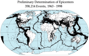
Kendrasthalasamuha earthquakes around the world, 1963-1998
After the devastating earthquake in April, another powerful earthquake shook Bangladesh on Monday morning. 6 to 7 percent from the quake's epicenter was 35 kilometers north-east of India in the state of Manipur. India 4am local time, 35 minutes, caused at least six people were killed and hundreds injured in the earthquake in the state of Manipur and some building walls, stairs and collapsed the roof have been reported. The quake was felt in almost all the places. Failure during an earthquake panic Dhaka, Rajshahi and Lalmonirhat three killed and rush out of the building, and at least 60 people across the country were reported to be injured. Bangshal a six-storey building has tilted at police; There was a crack house samkharibajarera.5 of 7 percent to 9 magnitude earthquake last April in Nepal's capital, Kathmandu, was sacked. In Nepal, more than two thousand people were killed. The fear of a heart attack during the earthquake collapsed the walls of houses in the country and 5 people died, hundreds were injured and eight. The next day, another earthquake of a garment factory collapsed in the rush to get out of the three, was killed in the stampede. A natural disaster of the earthquake, which has come to dominate the way to prevent. Even as the rainy storm is not possible to predict. So there is no way to avoid it, just to try to limit the damage. Various safety measures and strategies to that end, and being discovered, being accepted, particularly in seismic areas.Over the course of plate tectonics.
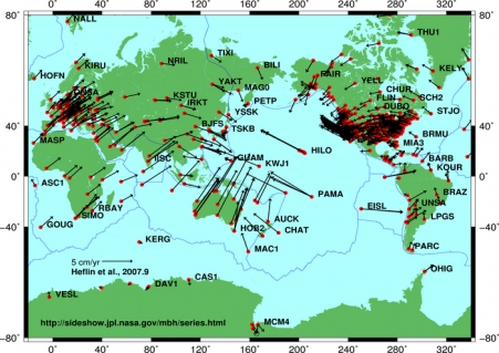
 India's north-eastern states of the Indian and Eurasian plates, the friction is often felt. Dauki Sylhet region of Bangladesh, a major earthquake faults due to increased risk of geologists has been warned. But the big question is how we watch it. The
construction of the country's most common violation of the rules, there
is an earthquake, a moderate decline in the construction of houses. Unplanned city is on the rise. Our ability delicate rescue operations after natural disasters like earthquakes. Nepal several times in the near-term seismic inversion and then taken as a warning for us is very important. We
need to limit the impact of the earthquake disaster in the landscape
construction and planned urbanization to ensure compliance with the
rules; Take the necessary steps to identify vulnerable infrastructure and housing. In these cases, the consequences of negligence and corruption, if condoned suicide, we need to understand it all. During the earthquake emergency measures as well as awareness exist. The cause of the casualties of the earthquake that happened in this country is largely due to panic and rush alarmed. Our focus will be to increase the capacity of the rescue operations.
India's north-eastern states of the Indian and Eurasian plates, the friction is often felt. Dauki Sylhet region of Bangladesh, a major earthquake faults due to increased risk of geologists has been warned. But the big question is how we watch it. The
construction of the country's most common violation of the rules, there
is an earthquake, a moderate decline in the construction of houses. Unplanned city is on the rise. Our ability delicate rescue operations after natural disasters like earthquakes. Nepal several times in the near-term seismic inversion and then taken as a warning for us is very important. We
need to limit the impact of the earthquake disaster in the landscape
construction and planned urbanization to ensure compliance with the
rules; Take the necessary steps to identify vulnerable infrastructure and housing. In these cases, the consequences of negligence and corruption, if condoned suicide, we need to understand it all. During the earthquake emergency measures as well as awareness exist. The cause of the casualties of the earthquake that happened in this country is largely due to panic and rush alarmed. Our focus will be to increase the capacity of the rescue operations.
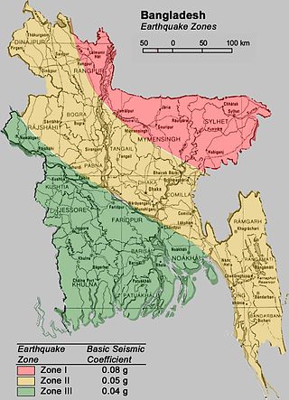
Bangladesh, on the basis of the severity of the earthquake has been divided into three zones. (Source: GSB)
Zone 1 include:
Rangpur, Rangpur, Kurigram, Jamalpur, Sherpur, Mymensingh, Netrokona,
Sunamganj, Kishoreganj, Maulvi Bazar, Sylhet, Habiganj, Brahmanbaria
full part, and Thakurgaon, Sirajganj, Tangail, Rangamati, part of Cox's
Bazar.Zone 1:Zone-1 is located in the Sylhet region most vulnerable to earthquake. Sunamganj
the country into India and has silanke daoki rivers and river daoki
this daoki Fault (Dauki fault) is along the border of the geological
cyutiguloi utpattisthalasiletera elakabarti major earthquake faults such
cyutigulora And some of the sub down, that the mountains are Patharia
earthquake and took Barlekha could be wiped out. The Patharia because antarcyuti (Patharia anticline) to swirl downward.Zone II are:Rajshahi, Natore, Magura, Meherpur, Comilla, Brahmanbaria, Feni and Dhaka.The Zone II
The district is located near the geologically active zone of the earthquake and the 1897 earthquake in the area was heavily damaged. Active earthquake area, due to the deadly quake in the region at any time, may be covered with bruises. However, in the region of 7 to 60 km from Madhopur 7.5 magnitude earthquake has become a geological fracture line. According to official sources on the night of 7 to 7.5 magnitude earthquake that killed and injured many people. During the day, but the number of casualties could reach almost dbigune. 326000 building in the Dhaka City Corporation conducted surveys on the severity of the earthquake that destroyed almost 72000 buildings will be damaged more than 85,000 buildings would be moderate. Just due to the demolition of the building will be 6 billion US dollars, equivalent asset losses. Even in 1999, the Risk Assessment Tools for Diagnosis of Urban Areas of the United Nations Against seismic diyasatara (radius) of the geological survey of risk capital in the world, 0 anyatamatacharao Tokyo Institute of Technology (TI) conducted by the Department of Geology of the University with the help of the recent ( 010) studies at different types of ground red clay soil, so the soil is soft. The city expanded to fill the water reservoir is built housing area. During the earthquake, soft soil and fill the earth quake led to waves of vibration, increases the intensity of the quake. The feature is added to the soil structure or deployment. The combination of the two increases-decreases the probability of an earthquake of intensity and casualties. Researchers at the town matisamrddha extension loose enough to feel vulnerable
Zone -3Barisal, Patuakhali, and all the islands and chars.
Nor is the earth quake area-based map prepared by BUET researchers found a high risk earthquake zone area covers 43% -1 41% and 16% of the area of the middle and lower risk zone is zone 3. 1993 map of the earth quake in the middle of 6%, 38% and 36% lower risk was high. According to the new map of the different degrees of awful position
Comments
Post a Comment